Everything Land,
All in One Place
Landstack‘s land information platform provides standardised planning and development data across the whole of Great Britain. Access planning applications, local plan policies, land availability assessments, comparable information, ownership, constraints, biodiversity net gain (BNG), and more through a powerful GIS system enhanced by industry-leading AI tools that let you query and report on any piece of land.


Landstack Pro is the ultimate site finding and evaluation tool. It allows you to take advantage of all of Landstack’s powerful AI and GIS features. This includes automated reporting, access to detailed local plan policy data, energy infrastructure data and more! Using Landstack’s mobile app, you can access all this land data on the go!

Detailed local authority land information
Keep up to date with everything that is happening in a Local Authority, from Local Plans down to Neighbourhood Plans, housing targets to affordable housing percentages and so much more with Landstack’s land intelligence!

Never miss a planning application
We collect planning applications across all Local Authorities in Great Britain and update them daily. We’ve built a powerful categorisation system within our land information platform that allows you to filter applications by use class, application type, important dates, appeal information and more!

Boundary data instead of points
We provide detailed boundaries on all our planning data sets giving you the best picture of development land across the country. Get access to detailed notes on each individual sites, this can range from planning application notes all the way to specific local plan policy detail.

Land data layers
Landstack uses a simple layering system to help users visualise and analyse land data. From this, users can see patterns and relationships in specific areas. Our land ownership data platform makes it easy to switch the layers on and off, providing clear insights for planning and development. This approach helps property professionals make data-driven decisions efficiently.


Take advantage of cutting-edge technology with Landstack AI

We’ve baked AI into every part of Landstack, you’ll be able to take advantage of:
Site finder
Describe the exact site you want, and site finder will do the rest. From the ideal commercial development to the next garden village, Site Finder will source your next opportunity in seconds.
Site appraisal
Generate a detailed, bespoke report on any piece of land you’d like. A site appraisal tool will go into access, land use, ownership, planning constraints, comparable information and more at the click of a button!
Chat bot
Want to know how much a piece of land is worth? Ask Landstack AI.
We’ve built an industry leading chat bot that allows you to get instant answers about any piece of land across Great Britain.


Streamlined but fully featured
Landstack Lite offers a free, streamlined version of our platform for accessing UK land development data, including planning applications, ownership information and more, with fewer tools and features than the comprehensive full version.

The Go-To Land Intelligence Platform


Stacking layers of data to give you the best view of development land in Britain
Detailed planning information with policy boundaries available for all our data. Load applications, allocations, Local Plan Policy, SHLAA, individually, or all at once.
- Land Registry
- Planning Applications
- Land Availability Assessments
- Call for sites
- Local Plan Policies
- House Price data
- Rightmove data
- Energy infrastructure
- BNG
- Land Marketplace
- and more!
Get Landstack data on your own system
Landstack offers two data APIs. Choose our Raster API to integrate straight into your own GIS system, or build Lanstack data directly into your software stack using our GraphQL API.


On the Landstack blog

The Greybelt Verdict
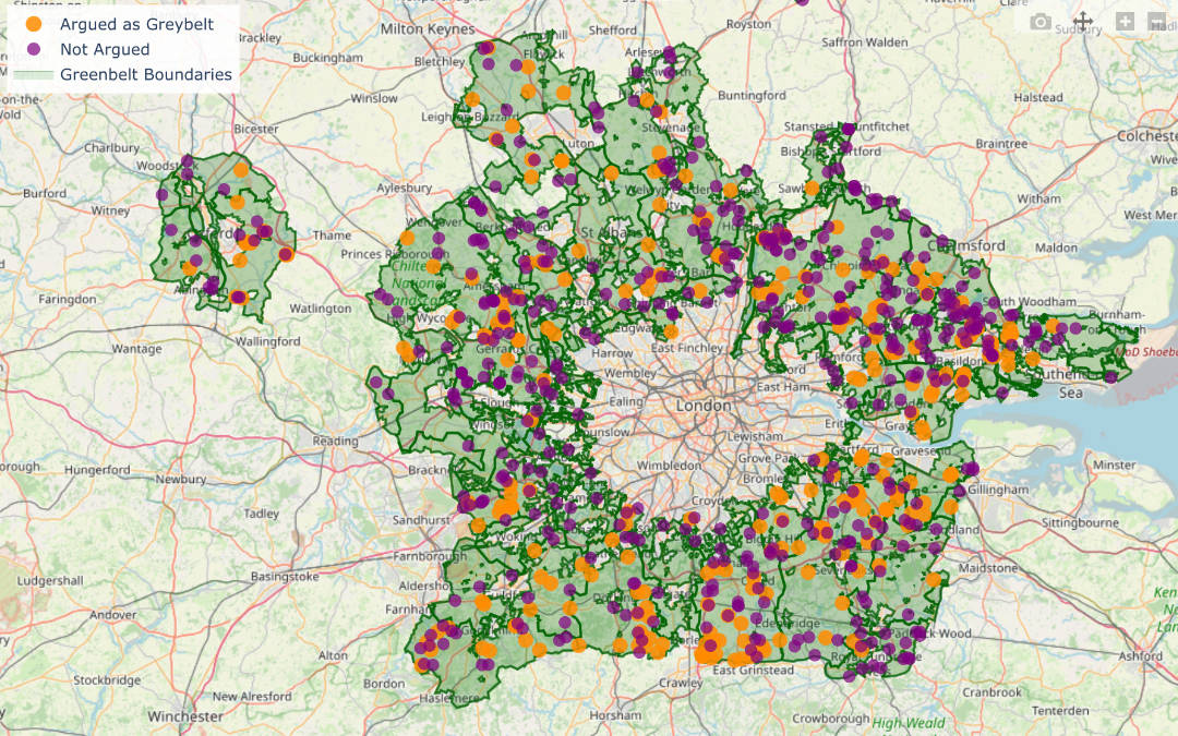
18 months in: Is Labour’s flagship planning policy delivering, or falling flat? An AI powered, data-driven analysis of 1,450 planning applications reveals how greybelt policy is really performing on the ground.

How Energy Infrastructure Shapes UK Development & Regeneration
Before a development project, there are a myriad of decisions and factors to consider. From the location to the surrounding facilities, and even the planning restrictions, no project is ever as simple as it might seem. While tools like our land information...

What Is an API? How It Connects GIS Systems to Planning Data
Planning teams often rely on tools such as GISs to ensure they have all the necessary data to complete their project. However, data access can be slow and fragmented, especially if it needs to be retrieved manually. That’s why APIs have become essential pieces of...


